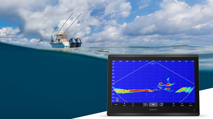
Garmin released the latest addition to its live sonar lineup. Powered by Garmin RapidReturn sonar technology, the Panoptix PS70, gives anglers a real-time view of what’s below the surface at greater depths. The fastest live sonar at 1,000 feet, the stainless steel thru-hull transducer is powered by Garmin RapidReturn sonar, which gives live sonar views up to 1,000 feet below the surface.
“Anglers have never seen live sonar images at depths like this or at this speed. Its wide sonar beam covers more of the water column at once and enables a quicker survey of the ocean floor in greater detail and can even show you where the targets are located, so it will take anglers less time to find bait, fish and structure—truly a game-changer for deep-sea sportfishing,” said Dan Bartel, Garmin vice president of Global Consumer Sales
With an 800-watt power output, the PS70 gives anglers stronger sonar penetration through the water with four adjustable sonar modes to fit a wide array of fishing techniques, including:
- LiveVü Down – Anglers can see small baitfish and target game fish in real-time up to 1,000 feet below the boat, while the wide 120-degree beam angle covers large areas of water.
- Traditional Sonar –Crisp, clear fish arches with separation of targets under the boat.
- Triple-Beam –A three-way traditional sonar split that gives returns from the port straight down and starboard in an understandable traditional sonar view. The beam angles are adjustable to fine-tune the three columns of sonar data.
- RealVü 3D Historical –Historical scanning technology finds fish and builds an ocean floor map while a boat moves. It shows the entire water column in 3D, from the bottom to the surface. The True Motion 3D sonar returns feature follows the vessel’s course over the ground.
The transducer also comes with image stabilization, allowing the device to adjust the sonar beams to continuously compensate for boat motion. Even in rough conditions, anglers will still see a steady sonar image.
With enhanced QuickDraw Contours, anglers can survey wide areas at depths up to 1,000 feet below the surface, making it easy to view and store their detailed contour maps in real-time. Users can contribute data to the QuickDraw Community to be integrated into Garmin Navionics+ charts or save their contours to their chart plotter.
The PS70 transducer can be flush or pocket mounted. It’s available alone or as a bundle with a fairing block for deadrise angles of 0 to 20 degrees and mounting hardware. It’s compatible with a wide range of Garmin GPSMAP chartplotters.
To learn more, go here.
Image courtesy Garmin